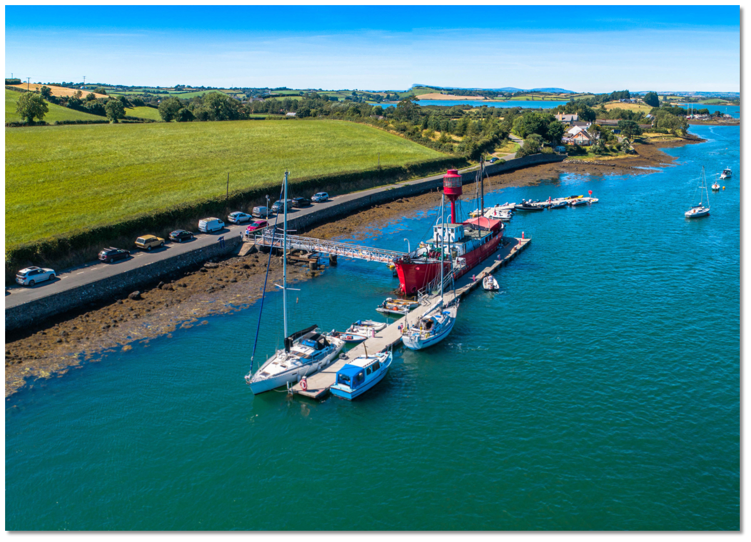
Ballydorn is a rural district in the Civil Parish of Killinchy on the western shore of Strangford Lough. It is surrounded on three sides by the Lough and connected to Sketrick Island and the castle to the east by a road causeway. Overlooked by the old church of Nendrum, on Mahee Island, it is home to the Down Cruising Club which has its base in a converted lightship that is moored afloat and called Petrel.
Ballydorn itself offers depths of 3 to 4 metres LAT but the entrance between Rainey and Sketrick Islands has only 1.5 metres at LWS and this is an important consideration for deeper draft vessels as is managing the tidal streams here.
All the waters of Ardmillan and Reagh bays are locked within the drumlin islands of the western shore that are mostly connected by causeways that were constructed in the nineteenth century. So these bays can only connect to Lough through the narrow channels between Mahee, Rainey and Sketrick Islands. As the waters ebb and flood between the Lough and Ardmillan and Reagh bays, this causes a tidal surge rushing past Ballydorn to fill or empty the bays that is almost as powerful as that experience in the Narrows. Spring rates can attain speeds of up to 5 knots when forced through the locked channels between the drumlin islands. Consequently, visitors need to be highly conscious of tides when operating here and it should be central to planning a visit.
Ideally, a first approach should be carefully timed to coincide with slack water. But if the vessel is carrying any draft it will be caught by the 1.5 metres at LWS in the approaches to off the northeast end of Sketrick Island and between it and Rainey Island. Hence the approach will need to be on the rise or at high water to be assured of sufficient depth and moderate streams. Making an entry with a following tide will make the approach swift and more challenging.
The very strong currents effectively rule out anchoring in the channel. There are four visitors' moorings available and should these be occupied the club will do their best to arrange a suitable vacant mooring. There are short-stay berths on the extended pontoons to the seaward side of the converted lightship.
This is moored off the west shore within the entrance channel between the islands. It has a 100 metres long pontoon and an extended dinghy dock and there is a gangway to the shore. Depths of 3 to 4 metres will be found on the outside berths. It is always best to contact Down Cruising Club in advance.
How to get in?
Use the approaches, tidal timings, the run up The Narrows and onward to Killyleagh, on the Lough's western shore, as covered in the Entering and exiting Strangford Lough  route description. Proceed up the deep water fairway on the Lough’s eastern side using Admiralty Chart 2156's Track E, F and H, to the Dead Man’s Rock Initial Fix. This is located a ¼ mile to the northeast of Dead Man’s Rock which is marked by a perch. Keep the perch on Dead Man’s Rock to port and proceed to the initial fix.
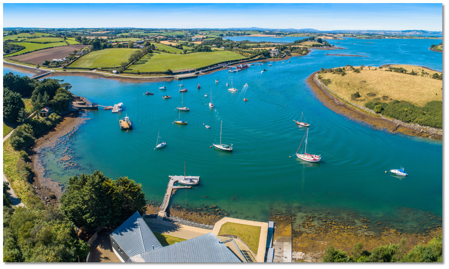
From the Initial Fix the path turns west by northwest for 1¼ miles passing Inishanier, Inisharoan and Trasnagh Islands to port (southward), until the channel opens between Sketrick and Rainey islands.
When between Sketrick and Rainey islands the helm should be watchful for unpredictable tidal flows that occur over the uneven channel contours. In addition to the strength of the current, the central current tends to flow very strongly one way whilst along the shores it can be streaming in the reverse direction. There are many moorings in the approaches to gauge the flow and closely moored boats can be seen to unaccountably pull in opposite directions at times on account of this.
Visitors should come alongside the pontoon and enquire if there is a spare visitor berth available, berth as instructed according to top prior contact. Take care when approaching the pontoon as the tide runs hard past it.
Once the vessel is well secured, report to the bar aboard where final berthing arrangements will be made. Berthing as instructed by the club offer.
All moorings in Ballydorn Bay are private and controlled by Ballydorn Fairway Committee under lease from the Crown Commissioners and should not be used by visitors without permission. If you need a mooring please approach the club manager to see if accommodations can be made. To help towards the lightship’s continuous maintenance there is a club charge to visitors.
It is possible to enter and exit to the north between Mahee and Rainey islands. However, there are a couple of points that are very narrow on the northern exit and currents may be further accelerated here.
At certain states of the tide, a standing wave will be seen to appear between Mahee and Rainey islands.

Position and approaches
Haven position: 54° 29.469' N, 005° 38.961' W
The position of the clubs decommissioned and permanently moored lightship 'Petrel' where you will find the club pontoons on the vessel's seaward side. It is located on the western side of Ballydorn fairway that is to the west of Rainey Island.
What is the initial fix?
The following Dead Man’s Rock Initial Fix will set up a final approach: 54° 28.980' N, 005° 36.200' W.
This is set on Admiralty Chart 2156's Track Ⓗ a ¼ mile northeast of Dead Man’s Rock.
What are the key points of the approach?
. Details for vessels approaching from the south are available in eastern Ireland’s Coastal Overview for Strangford Lough to Dublin Bay . Details of the approaches, tidal timings, the run up The Narrows and onward to Killyleagh, on the Lough's western shore, are covered in the Entering and exiting Strangford Lough route description.Not what you need?
- White Rock Bay - 0.6 miles SE
- Ringhaddy Sound - 2.6 miles SSE
- Pawle Island - 3.1 miles SSE
- Kircubbin - 3.8 miles E
- Simmy Island - 4 miles S
- East Down Yacht Club - 4.6 miles S
- Don O’Neill Island - 4.9 miles SSE
- Holm Bay - 5 miles S
- Killyleagh - 5.6 miles S
- Between Jackdaw & Chapel Island - 6.6 miles SSE